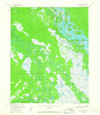
1956 Map of Fort Yukon A-2
USGS Topo · Published 1967About this map
The Yukon River dominates this northern Alaskan interior, carving a massive, braided channel through an intricate network of sloughs and sandbars in the mid-1950s. The presence of Saloon Island and the specifically noted Halfway Whirlpool suggests the navigational hazards and landmarks known to river travelers before modern aviation became the primary means of transit. To the south, the terrain transitions into a dense labyrinth of oxbow lakes and meandering tributaries, most notably Birch Creek and Little Preacher Creek. This landscape is defined by its water-rich geography, where named features like Crosstrail Lake and the Geese Lakes provided critical orientation points for those moving through the bush. The mapping effort, based on aerial photography from 1952 and 1953, recorded precisely surveyed elevations at locations such as VABM Preacher 527 and VABM Trail 495, marking the progress of formal surveying in this vast wilderness.
Find a feature on this map
9 named features on this map. Tap any name to fly to it.
Don’t see what you’re looking for? This feature index may not catch every label — zoom into the map to look around manually.
Map Details
Editions of this 1956 Fort Yukon A-2 Map
2 editions found
Other maps of this area

1951 · Fort Yukon
USGS Topo · 1:250,000

1951 · Circle
USGS Topo · 1:250,000

1952 · Circle D-3
USGS Topo · 1:63,360

1952 · Circle D-2
USGS Topo · 1:63,360

1955 · Circle D-1
USGS Topo · 1:63,360

1955 · Circle
USGS Topo · 1:250,000

1956 · Fort Yukon A-2
USGS Topo · 1:63,360

1956 · Fort Yukon B-3
USGS Topo · 1:63,360

1956 · Fort Yukon B-1
USGS Topo · 1:63,360

1956 · Fort Yukon A-1
USGS Topo · 1:63,360