
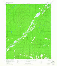
1952 Map of Circle D-3
USGS Topo · Published 1959About this map
The Crazy Mountains and the Little Crazy Mountains dominate this high-latitude landscape, where the drainage systems of the Yukon-Koyukuk region are meticulously documented through aerial photogrammetry. Central to this map is the meandering course of Preacher Creek, which weaves through a wide, swampy valley floor. This intricate water network is further defined by tributaries such as Discovery Creek, Rock Creek, and Minto Creek. The survey, based on 1951 aerial photography and 1952 field annotations, reveals a wilderness devoid of roads or permanent settlements at the time of mapping. This absence of infrastructure highlights the topographic isolation of the era, offering a baseline for geologists and researchers studying the natural drainage patterns and landforms of the Alaska interior before later development or environmental shifts.
Find a feature on this map
6 named features on this map. Tap any name to fly to it.
Don’t see what you’re looking for? This feature index may not catch every label — zoom into the map to look around manually.
Map Details
Editions of this 1952 Circle D-3 Map
2 editions found
Other maps of this area

1951 · Fort Yukon
USGS Topo · 1:250,000

1951 · Circle
USGS Topo · 1:250,000

1952 · Circle D-4
USGS Topo · 1:63,360

1952 · Circle D-2
USGS Topo · 1:63,360

1952 · Circle C-4
USGS Topo · 1:63,360

1955 · Circle C-3
USGS Topo · 1:63,360

1955 · Circle C-2
USGS Topo · 1:63,360

1955 · Circle
USGS Topo · 1:250,000

1956 · Fort Yukon A-2
USGS Topo · 1:63,360

1956 · Fort Yukon A-4
USGS Topo · 1:63,360