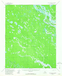
1956 Map of Fort Yukon B-3
USGS Topo · Published 1963About this map
The Yukon River and its intricate drainage network dominate this mid-century survey of the Alaskan interior. The landscape is defined by the braided path of the river and the expansive Seventeenmile Slough, which isolate substantial landforms like Twelvemile Island. To the south, the terrain transitions into a complex of wetlands and ponds known as the Hat Lie Lakes, where Birch Creek meanders toward Egil Island.
Find a feature on this map
12 named features on this map. Tap any name to fly to it.
Don’t see what you’re looking for? This feature index may not catch every label — zoom into the map to look around manually.
Map Details
Editions of this 1956 Fort Yukon B-3 Map
2 editions found
Other maps of this area

1951 · Fort Yukon
USGS Topo · 1:250,000

1952 · Fort Yukon C-2
USGS Topo · 1:63,360

1952 · Fort Yukon C-3
USGS Topo · 1:63,360

1952 · Fort Yukon C-4
USGS Topo · 1:63,360

1955 · Fort Yukon C-3
USGS Topo · 1:63,360

1956 · Fort Yukon B-4
USGS Topo · 1:63,360

1956 · Fort Yukon A-2
USGS Topo · 1:63,360

1956 · Fort Yukon A-4
USGS Topo · 1:63,360

1956 · Fort Yukon B-3
USGS Topo · 1:63,360

1956 · Fort Yukon B-2
USGS Topo · 1:63,360