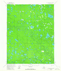
1956 Map of Fort Yukon B-4
USGS Topo · Published 1964About this map
Birch Creek dominates this interior Alaskan landscape, shown in a complex series of meandering loops and oxbows typical of the Yukon Flats. The mapping, based on 1952 aerial photography, documents the intricate drainage system where the Upper Mouth Birch Creek and Lower Mouth Birch Creek divide and reconnect across a low-lying basin. Numerous named water bodies like Twelvemile Lake and Tlozhavun Lake indicate a territory defined more by its seasonal water levels than by permanent land travel. Human presence is recorded through a sparse network of overland routes, most notably a Winter Trail that cuts across the northern terrain, and a singular Trail passing near Chisspvun Lake. This survey provides a baseline of the hydrologic pattern before significant modern changes, preserving the locations of Hattie Lakes and Tajittro Creek as they existed in the mid-1950s.
Find a feature on this map
11 named features on this map. Tap any name to fly to it.
Don’t see what you’re looking for? This feature index may not catch every label — zoom into the map to look around manually.
Map Details
Editions of this 1956 Fort Yukon B-4 Map
2 editions found
Other maps of this area

1951 · Fort Yukon
USGS Topo · 1:250,000

1952 · Fort Yukon C-3
USGS Topo · 1:63,360

1952 · Fort Yukon C-4
USGS Topo · 1:63,360

1955 · Fort Yukon C-3
USGS Topo · 1:63,360

1955 · Fort Yukon C-5
USGS Topo · 1:63,360

1956 · Fort Yukon B-4
USGS Topo · 1:63,360

1956 · Fort Yukon A-4
USGS Topo · 1:63,360

1956 · Fort Yukon B-3
USGS Topo · 1:63,360

1956 · Fort Yukon C-5
USGS Topo · 1:63,360

1956 · Fort Yukon A-5
USGS Topo · 1:63,360