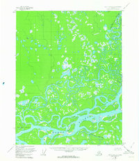
1956 Map of Fort Yukon C-5
USGS Topo · Published 1963About this map
The Yukon River dominates this mid-century subarctic landscape, carving a complex network of braids and bypasses through the interior wilderness. This 1950s survey captures the intricate hydrology of the region, where the Chandalar River joins the system and Crazy Slough meanders through the wetlands. Evidence of human presence is sparse but specific, marked by the Johnnie the Frog Cabin and other isolated Cabins along the water's edge, likely serving as essential waypoints for trappers or travelers. The eastern portion of the map includes a section of the Venetie Indian Reservation, defined by the Res Bdy. Landforms like Deadman Island and Willow Pt provide fixed navigation points in an environment where the Birch Creek (Upper Mouth) and shifting lake systems like Bearman Lake illustrate the dynamic nature of the Yukon flats.
Find a feature on this map
13 named features on this map. Tap any name to fly to it.
Don’t see what you’re looking for? This feature index may not catch every label — zoom into the map to look around manually.
Map Details
Editions of this 1956 Fort Yukon C-5 Map
2 editions found
Other maps of this area

1951 · Fort Yukon
USGS Topo · 1:250,000

1952 · Fort Yukon C-4
USGS Topo · 1:63,360

1955 · Fort Yukon D-4
USGS Topo · 1:63,360

1955 · Fort Yukon D-5
USGS Topo · 1:63,360

1955 · Fort Yukon C-5
USGS Topo · 1:63,360

1956 · Fort Yukon B-6
USGS Topo · 1:63,360

1956 · Fort Yukon B-4
USGS Topo · 1:63,360

1956 · Fort Yukon C-5
USGS Topo · 1:63,360

1956 · Fort Yukon B-5
USGS Topo · 1:63,360

1956 · Fort Yukon
USGS Topo · 1:250,000