Old Maps of Bessie No. 5 Dredge Camp, Alaska for Hiking & Exploration
Hike through history with 5 historic maps of Bessie No. 5 Dredge Camp. Explore old trails, ghost towns, and forgotten backroads — perfect for outdoor adventurers and local explorers.
- Rediscover forgotten places: Map out old mining camps, roads, and footpaths that no longer exist on modern maps.
- Layer with modern tools: Combine with LiDAR or satellite views to plan hikes through historical terrain.
- Made for exploration: Popular among hikers, overlanders, and local history lovers.
Use these maps to find adventure and explore the hidden past of Bessie No. 5 Dredge Camp.
Bessie No. 5 Dredge Camp, AK maps
(5)- 1950 Map of Nome, 1956 Print
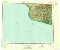 1950 Nome1956 Print · USGSThe Seward Peninsula at mid-century reveals a remote landscape of mining camps and coastal outposts. Researchers can trace the gold-dredging heritage of Bessie No. 5 Dredge Camp, the old Winter Trail, and the military site at Fort Davis.5 unique versions available
 - 1950 Map of Nome C-1, 1956 Print
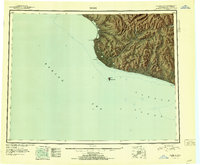
 1950 Nome C-11956 Print · USGSMid-century Nome is shown as a bustling aviation and mining center during the early fifties. Genealogists and historians can trace the Seward Peninsula RR past Perkinsville or locate the Miocene Ditch and Nome Municipal Airport.4 unique versions available
 - 1951 Map of Nome
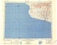
 1951 Nome1951 Print · USGSThe Seward Peninsula at the start of the 1950s shows the vital connection between its gold-mining history and the Bering Sea coast. Local historians can trace the remote outposts of Jensens Camp, the boundaries of Fort Davis (Military Res), and early aviation sites like the Landing Area.2 unique versions available
 - 1957 Map of Nome
 1957 Nome1957 Print · USGSThe Seward Peninsula comes alive in the mid-fifties, showing the mining camps and coastal outposts of the Norton Sound. Genealogists and historians can trace old sites like Jensens Camp, Fort Davis, and the Dredge Camp along the shores near Nome.
 - 2017 Map of Nome C-1 SE, 2017 Print
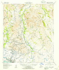
 2017 Nome C-1 SE2017 Print · USGSThe Seward Peninsula interior comes into focus during this modern survey, revealing a landscape etched by the history of the gold rush. You can trace the drainage of Army Peak through prospector-named features like Gold Gulch, Birthday Gulch, and Discovery Cr.
End of results
Showing maps 1-5 of 5
Top cities near Bessie No. 5 Dredge Camp
Frequently asked questions
- What are the different types of historical maps available for Bessie No. 5 Dredge Camp?
- What is the oldest map of Bessie No. 5 Dredge Camp?
- Where can I purchase historical maps of Bessie No. 5 Dredge Camp for my home or office?
- Where can I download high-res historical maps of Bessie No. 5 Dredge Camp?
- Are there historical topographic maps available for Bessie No. 5 Dredge Camp?
- Is there historical aerial imagery available for Bessie No. 5 Dredge Camp?
- Where are historical maps of Bessie No. 5 Dredge Camp sourced from?