Old Maps of Bettles, Alaska for Hiking & Exploration
Hike through history with 5 historic maps of Bettles. Explore old trails, ghost towns, and forgotten backroads — perfect for outdoor adventurers and local explorers.
- Rediscover forgotten places: Map out old mining camps, roads, and footpaths that no longer exist on modern maps.
- Layer with modern tools: Combine with LiDAR or satellite views to plan hikes through historical terrain.
- Made for exploration: Popular among hikers, overlanders, and local history lovers.
Use these maps to find adventure and explore the hidden past of Bettles.
Bettles, AK maps
(5)- 1951 Map of Bettles, 1952 Print
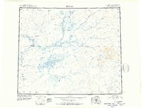 1951 Bettles1952 Print · USGSThe Koyukuk River valley appears in the early fifties as a landscape of isolated outposts and river-born travel. Trace the paths of the Winter Trail and the remote outposts at Bettles, Allakaket, and the Alatna Landing Area.
 - 1956 Map of Bettles, 1958 Print
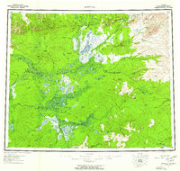 1956 Bettles1958 Print · USGSThe Alaskan interior during the mid-fifties reveals a landscape defined by winter trails and river navigation. Local historians can trace the foundations of Evansville, the neighboring communities of Allakaket and Alatna, and remote sites like Oscars Cabin.10 unique versions available
 - 1970 Map of Bettles D-4, 1973 Print
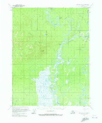 1970 Bettles D-41973 Print · USGSThe Koyukuk River backcountry comes into focus during the early seventies, centered on the aviation and river hub of Evansville. Researchers can trace the Winter Trail and locate remote sites like the Bettles Cem, Bettles Field, and Pitchuk Lake.2 unique versions available
 - 2016 Map of Bettles D-4 NE, 2016 Print
 2016 Bettles D-4 NE2016 Print · USGSCovers Bettles, including Evansville, Unorganized Borough, and other nearby areas
 - 2019 Map of Bettles D-4 NE, 2019 Print
 2019 Bettles D-4 NE2019 Print · USGSThe community of Bettles stands as a vital aviation and river junction in the Alaskan interior during the late twenty-teens. Researchers can trace the local road network around Bettles Airport and the seasonal Hickel Highway near the Koyukuk River.
End of results
Showing maps 1-5 of 5
Top cities near Bettles
Frequently asked questions
- What are the different types of historical maps available for Bettles?
- What is the oldest map of Bettles?
- Where can I purchase historical maps of Bettles for my home or office?
- Where can I download high-res historical maps of Bettles?
- Are there historical topographic maps available for Bettles?
- Is there historical aerial imagery available for Bettles?
- Where are historical maps of Bettles sourced from?