1951 Map of Bettles
USGS Topo · Published 1952About this map
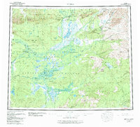
The Arctic Circle bisects this subarctic landscape, crossing the Koyukuk River and its major tributaries during a period of transition in the Alaskan interior. Compiled from 1940s photography and earlier surveys, the map reveals a wilderness defined by its water routes and isolated outposts. The settlement of Bettles is shown at the confluence of the John River and the Koyukuk River, served by a nearby airport that reflects the increasing reliance on aviation for northern logistics. Further west, the historic mission site at Allakaket sits near the Alatna Landing Area, while numerous cabin and cabins labels denote small trapping or prospector dwellings along the Kanuti River and Alatna River. High points like Lookout Mtn and Caribou Mtn rise above a complex network of wetlands including Lake Mentanontli and the Winter Trail.
Find a feature on this map
27 named features on this map. Tap any name to fly to it.
Don’t see what you’re looking for? This feature index may not catch every label — zoom into the map to look around manually.
Map Details
Editions of this 1951 Bettles Map
This is the sole edition of this map. No revisions or reprints were ever made.