
1951 Map of Melozitna
USGS Topo · Published 1952About this map
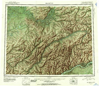
The Yukon River and Koyukuk River dominate this interior Alaskan landscape, which was compiled from trimetrogon photography and original surveys during the 1940s. The region is defined by the massive drainage systems of the Melozitna River and its tributaries, such as the Little Melozitna River and Melozimoran Creek. Human presence is sparse, centered on small outposts like Birches and Kallands along the southern riverbank, and isolated sites like Treat Island and Winthrop Point to the north.
Find a feature on this map
29 named features on this map. Tap any name to fly to it.
Don’t see what you’re looking for? This feature index may not catch every label — zoom into the map to look around manually.
Map Details
Editions of this 1951 Melozitna Map
2 editions found
Other maps of this area

1945 · Nulato
USGS Topo · 1:250,000

1948 · Kantishna River
USGS Topo · 1:250,000

1951 · Shungnak
USGS Topo · 1:250,000

1951 · Nulato
USGS Topo · 1:250,000

1951 · Kantishna River
USGS Topo · 1:250,000

1951 · Ruby
USGS Topo · 1:250,000

1951 · Kateel River
USGS Topo · 1:250,000

1951 · Hughes
USGS Topo · 1:250,000

1951 · Bettles
USGS Topo · 1:250,000

1951 · Tanana
USGS Topo · 1:250,000