
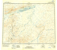
1951 Map of Ruby
USGS Topo · Published 1951About this map
The Yukon River flows past the riverfront settlement of Ruby, providing a vital northern transportation artery during this mid-century reconnaissance era. The landscape to the south transitions into the complex drainage systems of the Kokwim Mountains, where the Sulatna River and Nowitna River carve through the interior. Evidence of the region's gold-mining legacy is prominent along the creeks, with a designated Placer Mine and several others identified near Long.
Find a feature on this map
91 named features on this map. Tap any name to fly to it.
Don’t see what you’re looking for? This feature index may not catch every label — zoom into the map to look around manually.
Map Details
Editions of this 1951 Ruby Map
2 editions found
Other maps of this area

1945 · Nulato
USGS Topo · 1:250,000

1948 · Kantishna River
USGS Topo · 1:250,000

1950 · Medfra
USGS Topo · 1:250,000

1951 · Ophir
USGS Topo · 1:250,000

1951 · Nulato
USGS Topo · 1:250,000

1951 · Kantishna River
USGS Topo · 1:250,000

1951 · Kateel River
USGS Topo · 1:250,000

1951 · Melozitna
USGS Topo · 1:250,000

1951 · Tanana
USGS Topo · 1:250,000

1952 · Mount McKinley
USGS Topo · 1:250,000