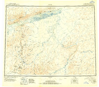
1951 Map of Ruby
USGS Topo · Published 1951About this map
The Yukon River serves as the primary artery for this remote Alaskan interior, where the settlement of Ruby stands as a vital hub against the northern slopes of the Kuskokwim Mountains. By the early 1950s, several outposts including Melozitna, Kokrines, and Placerville are noted as abandoned, signaling a shift in the region's mining and trade patterns. The map documents an economy driven by resource extraction, with numerous Placer Mines located along the tributaries of the Sulatna River, such as Greenstone Creek and Midnight Creek.
Find a feature on this map
86 named features on this map. Tap any name to fly to it.
Don’t see what you’re looking for? This feature index may not catch every label — zoom into the map to look around manually.
Map Details
Editions of this 1951 Ruby Map
2 editions found
Other maps of this area

1945 · Nulato
USGS Topo · 1:250,000

1948 · Kantishna River
USGS Topo · 1:250,000

1950 · Medfra
USGS Topo · 1:250,000

1951 · Ophir
USGS Topo · 1:250,000

1951 · Nulato
USGS Topo · 1:250,000

1951 · Kantishna River
USGS Topo · 1:250,000

1951 · Ruby
USGS Topo · 1:250,000

1951 · Kateel River
USGS Topo · 1:250,000

1951 · Melozitna
USGS Topo · 1:250,000

1951 · Tanana
USGS Topo · 1:250,000