
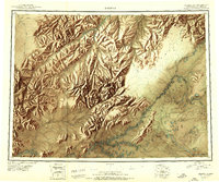
1950 Map of Medfra
USGS Topo · Published 1950About this map
The Kuskokwim River and its major tributaries, including the North Fork, South Fork, and East Fork, dominate this mid-century interior landscape. At the junction of the Nixon Fork and the main river lies Medfra, serving as a primary point of navigation in a region defined by high peaks and winding waterways. The presence of the Nixon Fork Mine, tucked near the Mystery Mountains, highlights the area's mineral prospects during the post-war era.
Find a feature on this map
65 named features on this map. Tap any name to fly to it.
Don’t see what you’re looking for? This feature index may not catch every label — zoom into the map to look around manually.
Map Details
Editions of this 1950 Medfra Map
2 editions found
Other maps of this area

1945 · Nulato
USGS Topo · 1:250,000

1948 · Kantishna River
USGS Topo · 1:250,000

1949 · McGrath
USGS Topo · 1:250,000

1950 · McGrath
USGS Topo · 1:250,000

1950 · Talkeetna
USGS Topo · 1:250,000

1951 · Talkeetna
USGS Topo · 1:250,000

1951 · Ophir
USGS Topo · 1:250,000

1951 · Nulato
USGS Topo · 1:250,000

1951 · Kantishna River
USGS Topo · 1:250,000

1951 · Ruby
USGS Topo · 1:250,000