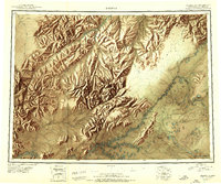
1950 Map of Medfra
USGS Topo · Published 1950About this map
The Kuskokwim River and its major tributaries define this mid-century reconnaissance of a remote Alaskan interior landscape. The map centers on the small settlement of Medfra, situated along the river near a landing field, which served as a critical node for transport and supply in a region devoid of developed roads. Economic activity of the era is anchored by the Nixon Fork Mine, located south of the Kuskokwim Mountains.
Find a feature on this map
70 named features on this map. Tap any name to fly to it.
Don’t see what you’re looking for? This feature index may not catch every label — zoom into the map to look around manually.
Map Details
Editions of this 1950 Medfra Map
2 editions found
Other maps of this area

1945 · Nulato
USGS Topo · 1:250,000

1948 · Kantishna River
USGS Topo · 1:250,000

1949 · McGrath
USGS Topo · 1:250,000

1950 · Medfra
USGS Topo · 1:250,000

1950 · McGrath
USGS Topo · 1:250,000

1950 · Talkeetna
USGS Topo · 1:250,000

1951 · Talkeetna
USGS Topo · 1:250,000

1951 · Ophir
USGS Topo · 1:250,000

1951 · Nulato
USGS Topo · 1:250,000

1951 · Kantishna River
USGS Topo · 1:250,000