
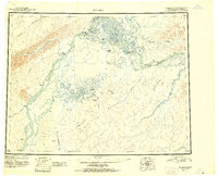
1951 Map of Nulato
USGS Topo · Published 1951About this map
The Yukon River and Koyukuk River confluence serves as the focal point for this interior Alaska landscape, documented just after mid-century. Small riverbank settlements like Koyukuk, Galena, and Louden appear as vital outposts along these massive waterways, which remained the primary transport arteries for the region. The intricate network of side channels and sloughs, including Kaiyuh Slough and Nikolai Slough, illustrates the dynamic nature of the Yukon floodplains, while the prominent Kaiyuh Mountains rise to the south.
Find a feature on this map
46 named features on this map. Tap any name to fly to it.
Don’t see what you’re looking for? This feature index may not catch every label — zoom into the map to look around manually.
Map Details
Editions of this 1951 Nulato Map
2 editions found
Other maps of this area

1945 · Nulato
USGS Topo · 1:250,000

1948 · Norton Bay
USGS Topo · 1:250,000

1950 · Medfra
USGS Topo · 1:250,000

1951 · Candle
USGS Topo · 1:250,000

1951 · Ophir
USGS Topo · 1:250,000

1951 · Unalakleet
USGS Topo · 1:250,000

1951 · Ruby
USGS Topo · 1:250,000

1951 · Norton Bay
USGS Topo · 1:250,000

1951 · Kateel River
USGS Topo · 1:250,000

1951 · Melozitna
USGS Topo · 1:250,000