Old Maps of Nulato, Alaska
Explore 8 old maps of Nulato, spanning from 1945 to today. These high-resolution historic maps reveal how streets, neighborhoods, landmarks, and natural features evolved over time — perfect for genealogy, metal detecting, research, and local history exploration.
What you can do with these maps:
- See how Nulato changed over time: Compare historical maps to modern-day views to trace roads, homesites, rail lines & more.
- View detailed metadata: Each map includes creators, publishers, year, scale, and archive source.
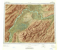
- Overlay maps with satellite & LiDAR: Visualize the past alongside modern tools to explore terrain & human change.
- Trusted historical sources: Maps sourced from the USGS, Library of Congress, and other archives.
- Access maps your way: View online, download high-res files, or order prints for personal or research use.
Start exploring old maps of Nulato to uncover forgotten places, hidden landmarks, and the deep history beneath your feet.
Nulato, AK maps
(8)- 1945 Map of Nulato, 1954 Print
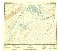 1945 Nulato1954 Print · USGSThe Yukon and Koyukuk rivers serve as the lifeblood of this Alaskan interior region during the mid-forties. Researchers can trace the traditional Kaltag Portage and locate established riverside settlements like Nulato, Galena, and the village at Koyukuk.2 unique versions available
 - 1951 Map of Nulato
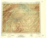 1951 Nulato1951 Print · USGSThe Yukon and Koyukuk Rivers meet in this mid-century Alaska survey, showing the vital river outposts and sloughs of the interior. Researchers can trace remote river life through landing areas at Galena, riverbank Cabins, and landmarks like Bishop Rock and Traders Island.2 unique versions available
 - 1952 Map of Nulato C-5, 1958 Print
 1952 Nulato C-51958 Print · USGSThe Yukon River interior comes alive in the early fifties, showing the vital river-based life of the Alaskan bush. Researchers can trace the Telegraph Line Abandoned and find seasonal landmarks like Ninemile Camp and the Airstrip at Nulato.
 - 1952 Map of Nulato, 1958 Print
 1952 Nulato1958 Print · USGSThe Yukon River interior comes into focus during the early fifties, documenting a region of river settlements and rising military aviation. Researchers can trace the Abandoned Telegraph Line, locate the Louden Cem, or study the footprint of the Galena Air Force Base.4 unique versions available
 - 1953 Map of Nulato C-5, 1962 Print
 1953 Nulato C-51962 Print · USGSThe Yukon River corridor near Nulato comes alive in the early 1950s, showing a landscape of river-dependent camps and early communication lines. Genealogists and historians can trace the Abandoned Telegraph Line, find local Fishing Cabins, or locate Benedum Landing and Nulato.2 unique versions available
 - 1964 Map of Nulato
 1964 Nulato1964 Print · USGSThe Yukon interior in the early sixties reveals a landscape shaped by river travel and Cold War aviation. Researchers can trace the ABANDONED TELEGRAPH LINE across the northern wilderness or locate historical sites like Nulato, Louden, and the Galena Air Force Base.
 - 2017 Map of Nulato C-5 NW, 2017 Print
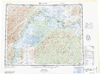
 2017 Nulato C-5 NW2017 Print · USGSThe interior of Alaska near the Yukon River is captured here in the late twenty-first century. Researchers can trace the path of the South Fork Nulato River as it approaches the settlement of Nulato and the great Yukon River.
 - 2017 Map of Nulato C-5 NE, 2017 Print
 2017 Nulato C-5 NE2017 Print · USGSThe riverfront settlement of Nulato is captured here in the early twenty-first century at the junction of the Yukon and Nulato Rivers. Genealogists and local historians can trace the community's layout from Cemetery Road to Front Street W and out toward Nulato Island.
End of results
Showing maps 1-8 of 8
Frequently asked questions
- What are the different types of historical maps available for Nulato?
- What is the oldest map of Nulato?
- Where can I purchase historical maps of Nulato for my home or office?
- Where can I download high-res historical maps of Nulato?
- Are there historical topographic maps available for Nulato?
- Is there historical aerial imagery available for Nulato?
- Where are historical maps of Nulato sourced from?