
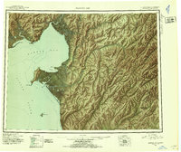
1948 Map of Norton Bay
USGS Topo · Published 1954About this map
Norton Bay Native Res and the Reindeer Reservation dominate the coastal landscape of this mid-century reconnaissance study, which details the eastern shores of Norton Sound. The map documents a critical network of overland travel and subsistence, marked by seasonal dwellings and essential stopovers like Isaac Roadhouse, Shaktolik Roadhouse, and Foothills Roadhouse.
Find a feature on this map
49 named features on this map. Tap any name to fly to it.
Don’t see what you’re looking for? This feature index may not catch every label — zoom into the map to look around manually.
Map Details
Editions of this 1948 Norton Bay Map
2 editions found
Other maps of this area

1945 · Nulato
USGS Topo · 1:250,000

1950 · Bendeleben A-1
USGS Topo · 1:63,360

1950 · Norton Bay D-6
USGS Topo · 1:63,360

1950 · Bendeleben
USGS Topo · 1:250,000

1950 · Norton Bay B-5
USGS Topo · 1:63,360

1950 · Norton Bay D-5
USGS Topo · 1:63,360

1950 · Solomon C-1
USGS Topo · 1:63,360

1950 · Norton Bay B-4
USGS Topo · 1:63,360

1950 · Norton Bay C-6
USGS Topo · 1:63,360

1950 · Solomon D-1
USGS Topo · 1:63,360