
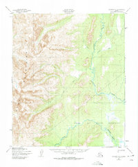
1950 Map of Solomon D-1
USGS Topo · Published 1956About this map
The Darby Mountains dominate the western landscape of this mid-century topographic survey, where steep ridgelines descend into the river valleys of the Seward Peninsula. A significant portion of the southeastern territory is occupied by the Norton Bay Native Reservation, reflecting the historical land designations of the era. The drainage systems of the Tubutulik River and the Kwiniuk River create intricate winding patterns across the lowlands, fed by tributaries like Vulcan Creek and Chukajak Creek. A notable logistical feature is the Winter Trail, which cuts across the tundra and foothills, providing a vital seasonal transportation route through this unpopulated wilderness. This 1950 data, compiled from aerial photography, shows the region before major modern infrastructure, focusing on the natural watercourses and the stark topography of the Darby range.
Find a feature on this map
8 named features on this map. Tap any name to fly to it.
Don’t see what you’re looking for? This feature index may not catch every label — zoom into the map to look around manually.
Map Details
Editions of this 1950 Solomon D-1 Map
2 editions found
Other maps of this area

1948 · Norton Bay
USGS Topo · 1:250,000

1950 · Bendeleben A-2
USGS Topo · 1:63,360

1950 · Bendeleben A-1
USGS Topo · 1:63,360

1950 · Norton Bay D-6
USGS Topo · 1:63,360

1950 · Solomon D-2
USGS Topo · 1:63,360

1950 · Solomon C-2
USGS Topo · 1:63,360

1950 · Bendeleben
USGS Topo · 1:250,000

1950 · Solomon C-1
USGS Topo · 1:63,360

1950 · Norton Bay C-6
USGS Topo · 1:63,360

1950 · Solomon
USGS Topo · 1:250,000