
1950 Map of Solomon C-2
USGS Topo · Published 1956About this map
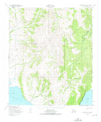
Native Reservation lands dominate this coastal Seward Peninsula landscape, bounded by the waters of Golovnin Bay to the southwest and Norton Bay to the east. At the time of this 1950 aerial survey, the region was defined by a critical network of overland routes including a prominent Telephone Line and several Winter Trails, one of which follows an approximate alignment through the interior toward the coast. These paths provided essential winter connectivity between isolated outposts like the Shelter near the shoreline and several Cabins scattered near the Kwiniuk River and Portage Creek. The drainage patterns, including Kachauik Creek and Cheenik Creek, reveal a landscape shaped by seasonal water flow and provide a record of the remote infrastructure required to navigate this portion of the Second Judicial Division before modern expansion.
Find a feature on this map
20 named features on this map. Tap any name to fly to it.
Don’t see what you’re looking for? This feature index may not catch every label — zoom into the map to look around manually.
Map Details
Editions of this 1950 Solomon C-2 Map
2 editions found
Other maps of this area

1950 · Solomon B-3
USGS Topo · 1:63,360

1950 · Solomon B-2
USGS Topo · 1:63,360

1950 · Solomon D-2
USGS Topo · 1:63,360

1950 · Solomon C-1
USGS Topo · 1:63,360

1950 · Solomon D-1
USGS Topo · 1:63,360

1950 · Solomon D-3
USGS Topo · 1:63,360

1950 · Solomon
USGS Topo · 1:250,000

1950 · Solomon C-3
USGS Topo · 1:63,360

1951 · Solomon
USGS Topo · 1:250,000

2014 · Solomon C-3 SE
USGS Topo · 1:25,000