
1950 Map of Bendeleben A-2
USGS Topo · Published 1955About this map
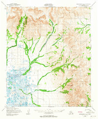
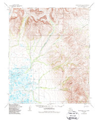
The Bendeleben Mountains dominate this high-latitude Alaskan landscape, casting a network of drainages that flow into the marshy flats of the Fish River. Mapped by the Army Map Service using 1950 aerial photography, the terrain is defined by its isolation and the logistical realities of mid-century exploration. The presence of the Telephone Trail and the noted Telephone Creek (Approximate Alignment) suggest a corridor of communication and transit through the Seward Peninsula interior. To the south, Omilak Mountain anchors a series of mineral-rich watercourses, including the North Fork Omilak Creek and South Fork Omilak Creek. This survey captures a moment where much of the land remained unchecked in the field, with labels like Lava Creek and Granite Creek hinting at the underlying geology of this northern wilderness.
Find a feature on this map
14 named features on this map. Tap any name to fly to it.
Don’t see what you’re looking for? This feature index may not catch every label — zoom into the map to look around manually.
Map Details
Editions of this 1950 Bendeleben A-2 Map
3 editions found
Other maps of this area

1950 · Bendeleben B-2
USGS Topo · 1:63,360

1950 · Bendeleben A-3
USGS Topo · 1:63,360

1950 · Bendeleben B-1
USGS Topo · 1:63,360

1950 · Bendeleben A-1
USGS Topo · 1:63,360

1950 · Bendeleben B-3
USGS Topo · 1:63,360

1950 · Solomon D-2
USGS Topo · 1:63,360

1950 · Bendeleben
USGS Topo · 1:250,000

1950 · Solomon D-1
USGS Topo · 1:63,360

1950 · Solomon D-3
USGS Topo · 1:63,360

1950 · Solomon
USGS Topo · 1:250,000