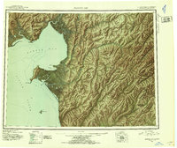
1948 Map of Norton Bay
USGS Topo · Published 1954About this map
Norton Bay Native Res and the Reindeer Reservation dominate the western coastline of this Alaskan reconnaissance study. The landscape is defined by the convergence of major waterways including the Koyuk River and Unalakleet River, which served as vital corridors for travel and subsistence. A network of overnight shelters like Isaac's Roadhouse, Shaktolik Roadhouse, and Old Woman Cabin highlights the infrastructure required for overland travel in the mid-century Arctic. The presence of the Kaltag Trail snaking through the Kaltag Mountains illustrates the historic portage route between the Norton Sound coast and the Yukon River interior. Small settlements and specialized landing sites, such as the Shaktolik Landing Area and Egavik, underscore the reliance on seasonal maritime and air access for these remote outposts.
Find a feature on this map
57 named features on this map. Tap any name to fly to it.
Don’t see what you’re looking for? This feature index may not catch every label — zoom into the map to look around manually.
Map Details
Editions of this 1948 Norton Bay Map
2 editions found
Other maps of this area

1945 · Nulato
USGS Topo · 1:250,000

1948 · Norton Bay
USGS Topo · 1:250,000

1950 · Bendeleben A-1
USGS Topo · 1:63,360

1950 · Norton Bay D-6
USGS Topo · 1:63,360

1950 · Bendeleben
USGS Topo · 1:250,000

1950 · Norton Bay B-5
USGS Topo · 1:63,360

1950 · Norton Bay D-5
USGS Topo · 1:63,360

1950 · Solomon C-1
USGS Topo · 1:63,360

1950 · Norton Bay B-4
USGS Topo · 1:63,360

1950 · Norton Bay C-6
USGS Topo · 1:63,360