Old Maps of Kokrines, Alaska
Explore 6 old maps of Kokrines, spanning from 1951 to today. These high-resolution historic maps reveal how streets, neighborhoods, landmarks, and natural features evolved over time — perfect for genealogy, metal detecting, research, and local history exploration.
What you can do with these maps:
- See how Kokrines changed over time: Compare historical maps to modern-day views to trace roads, homesites, rail lines & more.
- View detailed metadata: Each map includes creators, publishers, year, scale, and archive source.
- Overlay maps with satellite & LiDAR: Visualize the past alongside modern tools to explore terrain & human change.
- Trusted historical sources: Maps sourced from the USGS, Library of Congress, and other archives.
- Access maps your way: View online, download high-res files, or order prints for personal or research use.
Start exploring old maps of Kokrines to uncover forgotten places, hidden landmarks, and the deep history beneath your feet.
Kokrines, AK maps
(6)- 1951 Map of Ruby
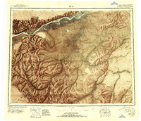 1951 Ruby1951 Print · USGSThe Yukon River interior comes to life in this mid-century study of the riverfront at Ruby and the surrounding gold-bearing creeks. Genealogists and historians can trace the seasonal routes of the Winter Trail, identify remote Placer Mines, and locate vanished sites like Placerville.2 unique versions available
 - 1952 Map of Ruby D-4, 1957 Print
 1952 Ruby D-41957 Print · USGSThe interior Alaska wilderness along the Yukon River is captured here in the early fifties, showing a landscape defined by water and isolation. Researchers can trace the Abandoned Telegraph Line near Kokrines or locate Homer Hot Springs and the remote cabins that dotted the riverbanks.
 - 1952 Map of Ruby, 1958 Print
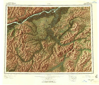 1952 Ruby1958 Print · USGSThe Yukon River interior comes to life in the early fifties, showing the remote mining camps and river life of the region. Genealogists and researchers can trace the Telegraph Line and find historic sites like Poorman, Placerville, and Sulatna Crossing.8 unique versions available
 - 1953 Map of Ruby D-4, 1967 Print
 1953 Ruby D-41967 Print · USGSThe Yukon River corridor near the Kokrines Hills was a vital interior artery during the early fifties. Researchers can trace the Abandoned Telegraph Line and locate isolated outposts like Kokrines or Horner Hot Springs.2 unique versions available
 - 1964 Map of Ruby
 1964 Ruby1964 Print · USGSAlaska's interior river country and gold districts are shown here during the mid-1960s, centered on the Yukon River corridor. Researchers can trace historic mining activity and remote outposts like Poorman, Placerville, and the Kokrines Cem.
 - 2019 Map of Ruby D-4 NE, 2019 Print
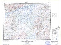
 2019 Ruby D-4 NE2019 Print · USGSThe Yukon-Koyukuk wilderness along the Yukon River is captured here in the early twenty-first century, showing a landscape of shifting sloughs and islands. Researchers can locate the riverside settlement of Kokrines and trace the winding paths of Junekaket Creek and Hardluck Slough.
End of results
Showing maps 1-6 of 6
Frequently asked questions
- What are the different types of historical maps available for Kokrines?
- What is the oldest map of Kokrines?
- Where can I purchase historical maps of Kokrines for my home or office?
- Where can I download high-res historical maps of Kokrines?
- Are there historical topographic maps available for Kokrines?
- Is there historical aerial imagery available for Kokrines?
- Where are historical maps of Kokrines sourced from?