Old Maps of Kokrines, Alaska for Metal Detecting
Plan your next treasure hunt with 6 historic maps of Kokrines. Find old homesites, ghost towns, trails, and gathering spots that may be lost to time — perfect for identifying promising metal detecting locations.
- Locate forgotten sites: Uncover places like long-lost settlements, abandoned rail lines, or gathering spots.
- Plan better hunts: Use map overlays combined with LiDAR or satellite views to narrow in on historically rich areas.
- Made for detectorists: Thousands of hobbyists use these maps to discover relics, coins, and hidden history.
Use these historic maps to boost your research and find new opportunities beneath the surface of Kokrines.
Kokrines, AK maps
(6)- 1951 Map of Ruby
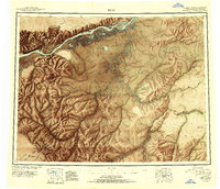 1951 Ruby1951 Print · USGSThe Yukon River interior comes to life in this mid-century study of the riverfront at Ruby and the surrounding gold-bearing creeks. Genealogists and historians can trace the seasonal routes of the Winter Trail, identify remote Placer Mines, and locate vanished sites like Placerville.2 unique versions available
 - 1952 Map of Ruby D-4, 1957 Print
 1952 Ruby D-41957 Print · USGSThe interior Alaska wilderness along the Yukon River is captured here in the early fifties, showing a landscape defined by water and isolation. Researchers can trace the Abandoned Telegraph Line near Kokrines or locate Homer Hot Springs and the remote cabins that dotted the riverbanks.
 - 1952 Map of Ruby, 1958 Print
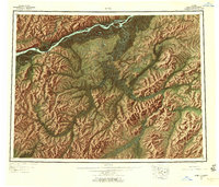 1952 Ruby1958 Print · USGSThe Yukon River interior comes to life in the early fifties, showing the remote mining camps and river life of the region. Genealogists and researchers can trace the Telegraph Line and find historic sites like Poorman, Placerville, and Sulatna Crossing.8 unique versions available
 - 1953 Map of Ruby D-4, 1967 Print
 1953 Ruby D-41967 Print · USGSThe Yukon River corridor near the Kokrines Hills was a vital interior artery during the early fifties. Researchers can trace the Abandoned Telegraph Line and locate isolated outposts like Kokrines or Horner Hot Springs.2 unique versions available
 - 1964 Map of Ruby
 1964 Ruby1964 Print · USGSAlaska's interior river country and gold districts are shown here during the mid-1960s, centered on the Yukon River corridor. Researchers can trace historic mining activity and remote outposts like Poorman, Placerville, and the Kokrines Cem.
 - 2019 Map of Ruby D-4 NE, 2019 Print
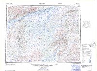
 2019 Ruby D-4 NE2019 Print · USGSThe Yukon-Koyukuk wilderness along the Yukon River is captured here in the early twenty-first century, showing a landscape of shifting sloughs and islands. Researchers can locate the riverside settlement of Kokrines and trace the winding paths of Junekaket Creek and Hardluck Slough.
End of results
Showing maps 1-6 of 6
Frequently asked questions
- What are the different types of historical maps available for Kokrines?
- What is the oldest map of Kokrines?
- Where can I purchase historical maps of Kokrines for my home or office?
- Where can I download high-res historical maps of Kokrines?
- Are there historical topographic maps available for Kokrines?
- Is there historical aerial imagery available for Kokrines?
- Where are historical maps of Kokrines sourced from?