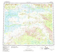
1951 Map of Shungnak
USGS Topo · Published 1951About this map
The Arctic Circle bisects this mid-century topographic survey, documenting a remote expanse of Northwest Alaska defined by its major river systems and high peaks. The settlement of Shungnak sits along the Kobuk River, serving as a focal point for the region's transport and activity near the confluence of Cosmos Creek and Dahl Creek. This survey was compiled using trimetrogon photography from the early 1940s and photoalidade methods in 1945, reflecting the period's advancements in mapping inaccessible terrain.
Find a feature on this map
33 named features on this map. Tap any name to fly to it.
Don’t see what you’re looking for? This feature index may not catch every label — zoom into the map to look around manually.
Map Details
Editions of this 1951 Shungnak Map
This is the sole edition of this map. No revisions or reprints were ever made.
Historical Maps of Shungnak Through Time
3 maps found