
1954 Map of Kateel River D-1
USGS Topo · Published 1959About this map
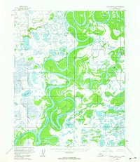
The Koyukuk River meanders through a dense network of wetlands and seasonal waterways in this mid-1950s interior Alaska survey. This riverine environment is defined by massive alluvial landforms such as Treat Island and Young Island, separated from the mainland by an intricate system of sloughs, including Huntington Slough and Cutoff Slough. The presence of the Old Cutoff Trading Post (Aband) suggests a shift in the local river-based economy, while a Fishing Camp and scattered Cabins indicate the continuing seasonal importance of the area for subsistence and trade. Large interior bodies of water like Whitefish Lake, Timber Lake, and First Lake dominate the low-lying plains between the larger river bends, illustrating the highly saturated landscape of the Yukon-Koyukuk region before contemporary changes to the drainage patterns.
Find a feature on this map
14 named features on this map. Tap any name to fly to it.
Don’t see what you’re looking for? This feature index may not catch every label — zoom into the map to look around manually.
Map Details
Editions of this 1954 Kateel River D-1 Map
2 editions found
Other maps of this area

1951 · Shungnak
USGS Topo · 1:250,000

1951 · Kateel River
USGS Topo · 1:250,000

1951 · Hughes
USGS Topo · 1:250,000

1951 · Melozitna
USGS Topo · 1:250,000

1954 · Kateel River C-2
USGS Topo · 1:63,360

1954 · Melozitna C-6
USGS Topo · 1:63,360

1954 · Kateel River C-1
USGS Topo · 1:63,360

1954 · Melozitna D-6
USGS Topo · 1:63,360

1955 · Shungnak
USGS Topo · 1:250,000

1955 · Kateel River D-2
USGS Topo · 1:63,360