
1954 Map of Melozitna D-6
USGS Topo · Published 1959About this map
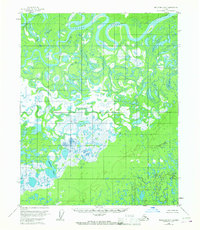
The Koyukuk River winds through this subarctic landscape in a complex series of tight oxbows and abandoned channels, defining the northern edge of a massive wetland system. This 1950s environment is dominated by the Dulbi Flats, a sprawling mosaic of marsh and water that includes features like Nododehon Lake. The intricate hydrology of the region is evident in the numerous secondary waterways such as Cutoff Slough, Messy Slough, and Nogoyalna Slough, which branch away from the main river channel around Treat Island. Human presence in this wilderness is minimal, represented only by a lone Cabin near the river and the landmark of Winthrop Point. The lack of roads or established trails on the map emphasizes the seasonal, river-dependent nature of travel and subsistence in the Yukon-Koyukuk region during the mid-20th century.
Find a feature on this map
9 named features on this map. Tap any name to fly to it.
Don’t see what you’re looking for? This feature index may not catch every label — zoom into the map to look around manually.
Map Details
Editions of this 1954 Melozitna D-6 Map
2 editions found
Other maps of this area

1951 · Shungnak
USGS Topo · 1:250,000

1951 · Kateel River
USGS Topo · 1:250,000

1951 · Hughes
USGS Topo · 1:250,000

1951 · Melozitna
USGS Topo · 1:250,000

1954 · Melozitna C-5
USGS Topo · 1:63,360

1954 · Melozitna C-6
USGS Topo · 1:63,360

1954 · Melozitna D-5
USGS Topo · 1:63,360

1954 · Kateel River C-1
USGS Topo · 1:63,360

1954 · Kateel River D-1
USGS Topo · 1:63,360

1955 · Shungnak
USGS Topo · 1:250,000