
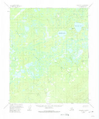
1954 Map of Melozitna C-6
USGS Topo · Published 1959About this map
The Dulbi Flats dominate this interior landscape, revealing a complex network of wetlands and meandering waterways in the Yukon-Koyukuk region. In the mid-1950s, the Nayuka River and Dulbi River defined the drainage patterns of this territory, where the rivers intersect amidst numerous unnamed ponds and sloughs. Evidence of human presence is remarkably sparse, limited to a single Cabin located north of Boatmakers Creek, suggesting a landscape primarily utilized for seasonal trapping or subsistence. Large bodies of water like Hahanudan Lake and Hadokhten Lake stand out as primary landmarks in the northeast. The presence of Dulbi Slough and various smaller drainages like Doba Creek illustrate the hydrologic character of the basin before any significant modern alterations or infrastructure reached this part of the Alaskan wilderness.
Find a feature on this map
10 named features on this map. Tap any name to fly to it.
Don’t see what you’re looking for? This feature index may not catch every label — zoom into the map to look around manually.
Map Details
Editions of this 1954 Melozitna C-6 Map
2 editions found
Other maps of this area

1951 · Kateel River
USGS Topo · 1:250,000

1951 · Melozitna
USGS Topo · 1:250,000

1952 · Kateel River B-1
USGS Topo · 1:63,360

1954 · Melozitna C-5
USGS Topo · 1:63,360

1954 · Melozitna D-5
USGS Topo · 1:63,360
1954 · Melozitna B-5
USGS Topo · 1:63,360

1954 · Kateel River C-1
USGS Topo · 1:63,360

1954 · Kateel River D-1
USGS Topo · 1:63,360

1954 · Melozitna D-6
USGS Topo · 1:63,360
1954 · Melozitna B-6
USGS Topo · 1:63,360