
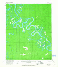
1954 Map of Melozitna D-5
USGS Topo · Published 1959About this map
The Koyukuk River dominates this mid-1950s interior Alaskan landscape, winding through a complex of oxbow lakes and marshes that characterize the Dulbi Flats. The river's extreme meanders illustrate a dynamic fluvial environment where landforms like Winthrop Point and Vabm Bank serve as rare fixed landmarks along the shifting watercourse. To the south and east, the terrain rises sharply away from the floodplain into the Takhakhdona Hills and toward the prominent summit of Bear Mountain. The northeastern portion of the quadrangle is defined by the high ground of Deniktaw Ridge, where drainage from Hot Springs Creek and Willow Creek flows back toward the main river valley. This survey, based on 1952 aerial photography, captures an unpopulated wilderness of the Yukon-Koyukuk region before any significant modern infrastructure reached these remote drainage basins.
Find a feature on this map
9 named features on this map. Tap any name to fly to it.
Don’t see what you’re looking for? This feature index may not catch every label — zoom into the map to look around manually.
Map Details
Editions of this 1954 Melozitna D-5 Map
2 editions found
Other maps of this area

1951 · Hughes
USGS Topo · 1:250,000

1951 · Melozitna
USGS Topo · 1:250,000

1954 · Melozitna C-4
USGS Topo · 1:63,360

1954 · Melozitna C-5
USGS Topo · 1:63,360

1954 · Melozitna C-6
USGS Topo · 1:63,360

1954 · Melozitna D-4
USGS Topo · 1:63,360

1954 · Melozitna D-6
USGS Topo · 1:63,360

1956 · Hughes
USGS Topo · 1:250,000

1956 · Melozitna
USGS Topo · 1:250,000

1964 · Hughes
USGS Topo · 1:250,000