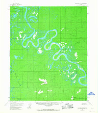
1954 Map of Melozitna D-5
USGS Topo · Published 1967About this map
The Koyukuk River winds through this Interior Alaska landscape, characterized by dramatic meanders and numerous oxbow lakes. In the mid-1950s, the river served as the primary corridor for movement through the region, flowing past notable landmarks such as Winthrop Point and VABM Bank 351. The drainage basin is joined by the Hogatza River, while the lower reaches are fed by Hot Springs Creek and Willow Creek.
Find a feature on this map
11 named features on this map. Tap any name to fly to it.
Don’t see what you’re looking for? This feature index may not catch every label — zoom into the map to look around manually.
Map Details
Editions of this 1954 Melozitna D-5 Map
2 editions found
Other maps of this area

1951 · Hughes
USGS Topo · 1:250,000

1951 · Melozitna
USGS Topo · 1:250,000

1954 · Melozitna C-4
USGS Topo · 1:63,360

1954 · Melozitna C-5
USGS Topo · 1:63,360

1954 · Melozitna C-6
USGS Topo · 1:63,360

1954 · Melozitna D-5
USGS Topo · 1:63,360

1954 · Melozitna D-4
USGS Topo · 1:63,360

1954 · Melozitna D-6
USGS Topo · 1:63,360

1956 · Hughes
USGS Topo · 1:250,000

1956 · Melozitna
USGS Topo · 1:250,000