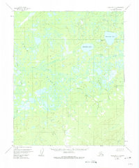
1954 Map of Melozitna C-6
USGS Topo · Published 1975About this map
The Nayuka River and the meandering Dulbi Slough dominate this interior Alaskan landscape, which was mapped via photogrammetric methods in the mid-1950s. The region is defined by extensive Flats and a complex network of waterways including Boatmakers Creek and Natnokoka Creek. Prominent water bodies such as Hahanudan Lake and Hadokhten Lake stand out amidst the marshy terrain. A solitary Cabin near the center of the sheet indicates a rare point of human habitation in a region characterized by its lack of established roads or trails. The map provides a detailed view of the natural hydrology as it existed before contemporary environmental changes, tracing tributaries like Tebukhti Creek and the smaller Hadotohedan Lake.
Find a feature on this map
10 named features on this map. Tap any name to fly to it.
Don’t see what you’re looking for? This feature index may not catch every label — zoom into the map to look around manually.
Map Details
Editions of this 1954 Melozitna C-6 Map
2 editions found
Other maps of this area

1951 · Kateel River
USGS Topo · 1:250,000

1951 · Melozitna
USGS Topo · 1:250,000

1952 · Kateel River B-1
USGS Topo · 1:63,360

1954 · Melozitna C-5
USGS Topo · 1:63,360

1954 · Melozitna C-6
USGS Topo · 1:63,360

1954 · Melozitna D-5
USGS Topo · 1:63,360
1954 · Melozitna B-5
USGS Topo · 1:63,360

1954 · Kateel River C-1
USGS Topo · 1:63,360

1954 · Kateel River D-1
USGS Topo · 1:63,360

1954 · Melozitna D-6
USGS Topo · 1:63,360