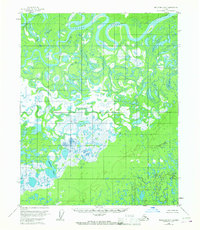
1954 Map of Melozitna D-6
USGS Topo · Published 1967About this map
The Koyukuk River winds through a dense network of waterways in this mid-century Alaskan interior landscape. The region is defined by its complex hydrologic patterns, where the main channel bypasses massive landforms like Treat Island and feeds into a series of bypasses including Cutoff Slough and Messy Slough. To the south, the terrain opens into the Dulbi Flats, a saturated lowland where the Nogoyalna Slough meanders toward the prominent Nododehon Lake. Based on 1952 aerial photography, the map reveals an environment of constant flux, with oxbows and intricate drainage systems that illustrate the shifting nature of the arctic floodplain. Apart from the geographical marker at Winthrop Point, the area remains largely devoid of permanent human infrastructure, reflecting the wilderness character of the Yukon-Koyukuk region during the 1950s.
Find a feature on this map
9 named features on this map. Tap any name to fly to it.
Don’t see what you’re looking for? This feature index may not catch every label — zoom into the map to look around manually.
Map Details
Editions of this 1954 Melozitna D-6 Map
2 editions found
Other maps of this area

1951 · Shungnak
USGS Topo · 1:250,000

1951 · Kateel River
USGS Topo · 1:250,000

1951 · Hughes
USGS Topo · 1:250,000

1951 · Melozitna
USGS Topo · 1:250,000

1954 · Melozitna C-5
USGS Topo · 1:63,360

1954 · Melozitna C-6
USGS Topo · 1:63,360

1954 · Melozitna D-5
USGS Topo · 1:63,360

1954 · Kateel River C-1
USGS Topo · 1:63,360

1954 · Kateel River D-1
USGS Topo · 1:63,360

1954 · Melozitna D-6
USGS Topo · 1:63,360