
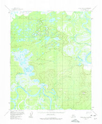
1954 Map of Kateel River C-2
USGS Topo · Published 1959About this map
The Koyukuk River and its intricate drainage system dominate this mid-century Alaskan interior landscape. The river’s winding course is mirrored by the Huslia River and Hogatza River, creating a complex network of active waterways and historical channels like Richards Slough. This environment is characterized by numerous interior water bodies, including Peter Cleaver Lake and Tsedolalindin Lake, which suggest a seasonally shifting floodplain.
Find a feature on this map
11 named features on this map. Tap any name to fly to it.
Don’t see what you’re looking for? This feature index may not catch every label — zoom into the map to look around manually.
Map Details
Editions of this 1954 Kateel River C-2 Map
2 editions found
Other maps of this area

1951 · Kateel River
USGS Topo · 1:250,000

1952 · Kateel River B-1
USGS Topo · 1:63,360

1952 · Kateel River B-3
USGS Topo · 1:63,360

1952 · Kateel River B-2
USGS Topo · 1:63,360

1954 · Kateel River C-1
USGS Topo · 1:63,360

1954 · Kateel River D-1
USGS Topo · 1:63,360

1954 · Kateel River C-3
USGS Topo · 1:63,360

1954 · Kateel River D-3
USGS Topo · 1:63,360

1955 · Kateel River D-2
USGS Topo · 1:63,360

1955 · Kateel River
USGS Topo · 1:250,000