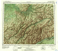
1951 Map of Melozitna
USGS Topo · Published 1952About this map
The Koyukuk River and Yukon River define this mid-century Alaskan landscape, where the vast drainage systems of the Melozitna River and Kokrines Hills dominate the interior. This reconnaissance study, compiled from trimetrogon photography taken during the early 1940s, reveals a territory organized around waterway transport and remote extraction. Small pockets of industry are evident at the Indian Placer Mine and a general Placer Mine near the northern boundary, while isolated outposts like Birches and Cabin represent the sparse human footprint in the Fourth Judicial Division. The map is particularly striking for its depiction of river morphology, showing complex meanders and islands such as Treat Island and Huggins Island, which were essential navigation landmarks for riverboats and bush pilots before the widespread development of road infrastructure in the region.
Find a feature on this map
25 named features on this map. Tap any name to fly to it.
Don’t see what you’re looking for? This feature index may not catch every label — zoom into the map to look around manually.
Map Details
Editions of this 1951 Melozitna Map
2 editions found
Other maps of this area

1945 · Nulato
USGS Topo · 1:250,000

1948 · Kantishna River
USGS Topo · 1:250,000

1951 · Shungnak
USGS Topo · 1:250,000

1951 · Nulato
USGS Topo · 1:250,000

1951 · Kantishna River
USGS Topo · 1:250,000

1951 · Ruby
USGS Topo · 1:250,000

1951 · Kateel River
USGS Topo · 1:250,000

1951 · Hughes
USGS Topo · 1:250,000

1951 · Melozitna
USGS Topo · 1:250,000

1951 · Bettles
USGS Topo · 1:250,000