Old Maps of Black, Alaska for Genealogy
Trace your family roots with 3 historic maps of Black. These high-res maps reveal old neighborhoods, homesites, landmarks, and streets — helping you uncover where your ancestors lived and how the area evolved over time.
- Explore historic neighborhoods: Identify where your relatives may have lived in the 1800s or 1900s.
- Compare maps over time: Trace the changes in streets, buildings, and landmarks for multi-generational research.
- Perfect for genealogy & ancestry research: Used by family historians and researchers to map out lineage and migration.
These maps are an incredible resource for exploring your personal connection to Black's past.
Black, AK maps
(3)- 1951 Map of Black
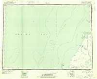 1951 Black1951 Print · USGSThe remote coast of the Yukon-Kuskokwim Delta is captured here in the early 1950s, showing a land of shifting channels and isolated outposts. Genealogy and history researchers can trace the locations of Bimiut and Black, or locate the site of Kogomiut (Aband).6 unique versions available
 - 1952 Map of Black B-1, 1958 Print
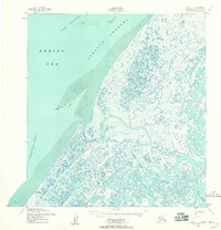 1952 Black B-11958 Print · USGSThe Bering Sea coast and the delta of the Black River are frozen in time during the early fifties. Local historians can trace seasonal routes like the Winter Trail and locate small riverside settlements such as Kwikak and Black.3 unique versions available
 - 2020 Map of Black B-1 SW, 2020 Print
 2020 Black B-1 SW2020 Print · USGSThe remote Alaskan coastline of the Kusilvak Census Area is captured here during the 2020s, showing the intersection of the Bering Sea and the tundra. Researchers can trace the winding paths of the Black River and the Kipniyagok River near the small settlement of Black.
End of results
Showing maps 1-3 of 3
Frequently asked questions
- What are the different types of historical maps available for Black?
- What is the oldest map of Black?
- Where can I purchase historical maps of Black for my home or office?
- Where can I download high-res historical maps of Black?
- Are there historical topographic maps available for Black?
- Is there historical aerial imagery available for Black?
- Where are historical maps of Black sourced from?