Old Maps of Caro, Alaska for Genealogy
Trace your family roots with 5 historic maps of Caro. These high-res maps reveal old neighborhoods, homesites, landmarks, and streets — helping you uncover where your ancestors lived and how the area evolved over time.
- Explore historic neighborhoods: Identify where your relatives may have lived in the 1800s or 1900s.
- Compare maps over time: Trace the changes in streets, buildings, and landmarks for multi-generational research.
- Perfect for genealogy & ancestry research: Used by family historians and researchers to map out lineage and migration.
These maps are an incredible resource for exploring your personal connection to Caro's past.
Caro, AK maps
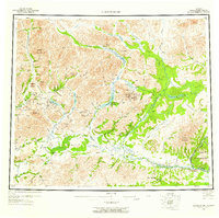
(5)- 1951 Map of Chandalar, 1952 Print
 1951 Chandalar1952 Print · USGSThe Brooks Range interior comes into focus in the early fifties, documenting a landscape of mining camps and river headwaters. Trace the legacy of gold prospectors through labels for the Beaver-Caro Wagon Road, the settlement of Caro, and the Gold Landing Strip.
 - 1956 Map of Chandalar, 1958 Print
 1956 Chandalar1958 Print · USGSThe Brooks Range wilderness of the mid-fifties is documented here through its complex river systems and isolated outposts. Researchers can locate the Venetie Indian Reservation and trace the Winter Trail past remote sites like Caro and Sixty-one Mile Cabin.8 unique versions available
 - 1964 Map of Chandalar
 1964 Chandalar1964 Print · USGSThe Alaskan interior during the mid-sixties reveals a landscape of isolated mining outposts and river-valley settlements connected by seasonal paths. Researchers can trace the Winter Trail through the hills or locate remote sites like Chandalar Mine, Venetie, and Sixty-one Mile Cabin.
 - 1990 Map of Chandalar A-3
 1990 Chandalar A-31990 Print · USGSThe Brooks Range foothills meet the northern wetlands in the late twentieth century, showing a remote landscape shaped by the Middle Fork Chandalar River. Trace the path of the Winter Trail as it passes through Caro and navigate the drainages of Monarch Creek and Mickey Creek.
 - 2017 Map of Chandalar A-3 NE, 2017 Print
 2017 Chandalar A-3 NE2017 Print · USGSThe northern Alaska interior near the settlement of Caro is captured here during the early twenty-first century. Researchers can trace the shifting braided channels of the Teedriinjik River and locate remote water bodies like Mary Lake and Kobuk Lake.
End of results
Showing maps 1-5 of 5
Frequently asked questions
- What are the different types of historical maps available for Caro?
- What is the oldest map of Caro?
- Where can I purchase historical maps of Caro for my home or office?
- Where can I download high-res historical maps of Caro?
- Are there historical topographic maps available for Caro?
- Is there historical aerial imagery available for Caro?
- Where are historical maps of Caro sourced from?