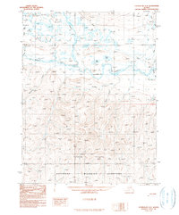
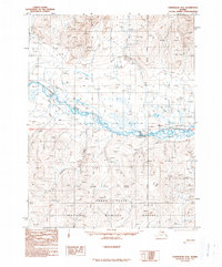
1990 Map of Chandalar A-3
USGS Topo · Published 1990About this map
The Middle Fork Chandalar River and North Fork Chandalar River dominate this interior Alaskan landscape, converging in a region of transition between high ridgelines and the low-lying wetlands of the Yukon Flats National Wildlife Refuge. The settlement at Caro sits at the eastern edge of the sheet, connected by a Winter Trail that weaves through the northern reaches. This 1990 provisional survey documents a wilderness landscape defined by hydrologic features like Mary Lake, Kobuk Lake, and the distinctive Pingo formation in the southwest. A network of drainages including Monarch Creek, Mickey Creek, and Flynn Creek flow from the central elevations toward the river valleys, while several scattered Cabin sites indicate the isolated human footprint in this subarctic environment prior to the turn of the century.
Find a feature on this map
19 named features on this map. Tap any name to fly to it.
Don’t see what you’re looking for? This feature index may not catch every label — zoom into the map to look around manually.
Map Details
Editions of this 1990 Chandalar A-3 Map
This is the sole edition of this map. No revisions or reprints were ever made.
Other maps of this area

1951 · Chandalar
USGS Topo · 1:250,000

1951 · Beaver
USGS Topo · 1:250,000

1956 · Chandalar
USGS Topo · 1:250,000

1956 · Beaver
USGS Topo · 1:250,000

1964 · Chandalar
USGS Topo · 1:250,000

1964 · Beaver
USGS Topo · 1:250,000
1970 · Beaver D-4
USGS Topo · 1:63,360
1970 · Chandalar A-4
USGS Topo · 1:63,360
1971 · Chandalar B-4
USGS Topo · 1:63,360
1990 · Chandalar A-2
USGS Topo · 1:63,360