Old Maps of Casadepaga, Alaska for Hiking & Exploration
Hike through history with 5 historic maps of Casadepaga. Explore old trails, ghost towns, and forgotten backroads — perfect for outdoor adventurers and local explorers.
- Rediscover forgotten places: Map out old mining camps, roads, and footpaths that no longer exist on modern maps.
- Layer with modern tools: Combine with LiDAR or satellite views to plan hikes through historical terrain.
- Made for exploration: Popular among hikers, overlanders, and local history lovers.
Use these maps to find adventure and explore the hidden past of Casadepaga.
Casadepaga, AK maps
(5)- 1907 Map of Casadepaga
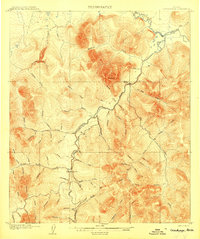 1907 Casadepaga1907 Print · USGSThe Seward Peninsula mining frontier is captured here at the height of early exploration, featuring the route of the Council City and Solomon River Railroad. Genealogists and historians can trace the early transit network and remote outposts like the Roadhouse and Mt Dixon.2 unique versions available
 - 1950 Map of Solomon, 1956 Print
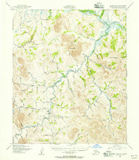
 1950 Solomon1956 Print · USGSThe southern Seward Peninsula is captured here in the mid-1950s, showing a landscape defined by coastal outposts and inland mining camps. Trace historic routes like the Winter Trail or locate the Big Hurrah Mine and Ruby Roadhouse.5 unique versions available
 - 1950 Map of Solomon D-5, 1956 Print
 1950 Solomon D-51956 Print · USGSThe Seward Peninsula interior at the dawn of the fifties reveals a landscape of gold-era transport and remote camps. Trace the SOLOMON RAILROAD, the Ruby Roadhouse, and historic routes like the CORDUROY ROAD and Military Trail.3 unique versions available
 - 1951 Map of Solomon
 1951 Solomon1951 Print · USGSThe Seward Peninsula during the mid-century shows the intricate network of mining trails and coastal outposts that followed the gold rushes. Researchers can trace the Seward Peninsula Railroad and locate interior settlements like Council or the Big Hurrah Mine.3 unique versions available
 - 2017 Map of Solomon D-5 SW, 2017 Print
 2017 Solomon D-5 SW2017 Print · USGSThe Seward Peninsula gold country is captured here in the mid-2010s, showing the complex hydrology of the Nome Census Area. Geologists and researchers can trace the drainages of the Casadepaga River and Solomon River through Homestake Gulch and Allgold Cr.
End of results
Showing maps 1-5 of 5
Frequently asked questions
- What are the different types of historical maps available for Casadepaga?
- What is the oldest map of Casadepaga?
- Where can I purchase historical maps of Casadepaga for my home or office?
- Where can I download high-res historical maps of Casadepaga?
- Are there historical topographic maps available for Casadepaga?
- Is there historical aerial imagery available for Casadepaga?
- Where are historical maps of Casadepaga sourced from?