Old Maps of Chakwaktolik, Alaska for Metal Detecting
Plan your next treasure hunt with 4 historic maps of Chakwaktolik. Find old homesites, ghost towns, trails, and gathering spots that may be lost to time — perfect for identifying promising metal detecting locations.
- Locate forgotten sites: Uncover places like long-lost settlements, abandoned rail lines, or gathering spots.
- Plan better hunts: Use map overlays combined with LiDAR or satellite views to narrow in on historically rich areas.
- Made for detectorists: Thousands of hobbyists use these maps to discover relics, coins, and hidden history.
Use these historic maps to boost your research and find new opportunities beneath the surface of Chakwaktolik.
Chakwaktolik, AK maps
(4)- 1951 Map of Marshall
 1951 Marshall1951 Print · USGSThe Yukon River corridor and its surrounding delta wetlands are documented here in the early fifties, showcasing the vital riverine economy of the day. Researchers can trace remote settlements and points of interest like Pilot Station, Marshall, and Owl Village.
 - 1953 Map of Marshall A-5, 1964 Print
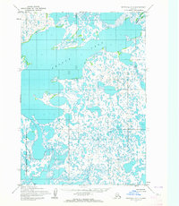 1953 Marshall A-51964 Print · USGSThe Yukon-Kuskokwim Delta in the early fifties is captured here as a sprawling wilderness of water and tundra. Researchers can trace the early boundaries of the Clarence Rhode National Wildlife Range and the massive Aropuk Lake.3 unique versions available
 - 1954 Map of Marshall, 1966 Print
 1954 Marshall1966 Print · USGSThe Yukon Delta and lower river system appear in intricate detail during the mid-fifties, showing the essential water routes and riverfront settlements of the era. Genealogists and researchers can locate Marshall (Fortuna Ledge PO), Pilot Station, and the seasonal Winter Trail crossing the frozen landscape.3 unique versions available
 - 2020 Map of Marshall A-5 NW, 2020 Print
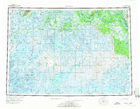
 2020 Marshall A-5 NW2020 Print · USGSThe Yukon-Kuskokwim Delta tundra is documented in this 2020 survey, showing a landscape defined by water and wetlands. Researchers can trace the extensive boundaries of Aropuk Lake and the grid systems of T13N R81W and T12N R82W.
End of results
Showing maps 1-4 of 4
Frequently asked questions
- What are the different types of historical maps available for Chakwaktolik?
- What is the oldest map of Chakwaktolik?
- Where can I purchase historical maps of Chakwaktolik for my home or office?
- Where can I download high-res historical maps of Chakwaktolik?
- Are there historical topographic maps available for Chakwaktolik?
- Is there historical aerial imagery available for Chakwaktolik?
- Where are historical maps of Chakwaktolik sourced from?