1951 Map of Marshall
USGS Topo · Published 1951About this map
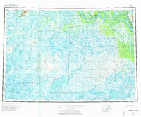
The Yukon River carves a complex path through this subarctic landscape, defining the northern corridor of the survey near Marshall (Fortuna Ledge PO). This regional hub, paired with Pilot Station, anchors the river's transport network amidst a maze of side channels like Driftwood Slough and Dogtooth Bend. The interior is characterized by expansive wetlands and isolated settlements such as Owl Village and Chukwoktulik, situated between the Kusilvak Mountain range to the northwest and the Ingakslugwat Hills to the south.
Find a feature on this map
51 named features on this map. Tap any name to fly to it.
Don’t see what you’re looking for? This feature index may not catch every label — zoom into the map to look around manually.
Map Details
Editions of this 1951 Marshall Map
This is the sole edition of this map. No revisions or reprints were ever made.