
1952 Map of Black A-1
USGS Topo · Published 1958About this map
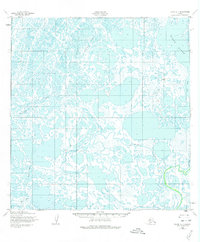
Black River meanders through an intricate landscape of hundreds of unnamed thaw lakes and wetlands in this portion of the Yukon-Kuskokwim Delta. Mapped by the Army Map Service using aerial photography from the early 1950s, the terrain is defined by its complex hydrologic patterns, where the Kipniyagok River and Melatolik Creek navigate a nearly level plain with elevations under fifty feet. The only indication of overland travel across this water-saturated environment is a seasonal Winter Trail (Approximate), which appears as a dashed line cutting through the tundra. This map provides a clear view of the natural drainage systems before significant modern changes, illustrating how waterbodies dominate the geography of the Alaskan coast in this era.
Find a feature on this map
4 named features on this map. Tap any name to fly to it.
Don’t see what you’re looking for? This feature index may not catch every label — zoom into the map to look around manually.
Map Details
Editions of this 1952 Black A-1 Map
2 editions found
Other maps of this area

1951 · Marshall
USGS Topo · 1:250,000

1951 · Hooper Bay
USGS Topo · 1:250,000

1951 · Black
USGS Topo · 1:250,000

1952 · Kwiguk
USGS Topo · 1:250,000

1952 · Black A-2
USGS Topo · 1:63,360

1952 · Black B-1
USGS Topo · 1:63,360

1952 · Kwiguk B-6
USGS Topo · 1:63,360

1952 · Kwiguk A-6
USGS Topo · 1:63,360
1952 · Hooper Bay D-1
USGS Topo · 1:63,360
1952 · Marshall D-8
USGS Topo · 1:63,360