1951 Map of Hooper Bay
USGS Topo · Published 1951About this map
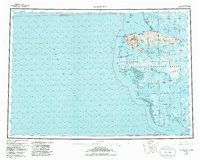
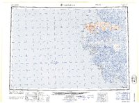
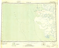
Cape Romanzof and the Askinuk Mountains dominate this 1951 reconnaissance of the Yukon-Kuskokwim Delta coastline. The map illustrates a complex network of coastal waterways and tundra rivers including the Kun River and Kashunuk River, which wind through expansive Mud Flats toward the Bering Sea. Small coastal settlements such as Scammon Bay, Kutmiut, and Hooper Bay are situated along the margins of protected inlets like Igiak Bay and Scammon Bay. A solitary Winter Trail provides a critical overland connection between the northern coastal settlements during the frozen months. This document, compiled from 1940s photography, preserves the mid-century geography of the region before modern infrastructure altered the traditional paths between the delta's villages.
Find a feature on this map
25 named features on this map. Tap any name to fly to it.
Don’t see what you’re looking for? This feature index may not catch every label — zoom into the map to look around manually.
Map Details
Editions of this 1951 Hooper Bay Map
This is the sole edition of this map. No revisions or reprints were ever made.
Historical Maps of Hooper Bay Through Time
3 maps found