
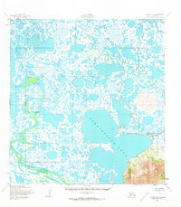
1952 Map of Kwiguk A-6
USGS Topo · Published 1959About this map
Nunavakanuk Lake dominates the central landscape of this 1950s survey, representing a vast labyrinth of water and tundra in the Yukon-Kuskokwim Delta. The map captures the complex hydrology of the region, where the Black River meanders through an intricate web of smaller lakes and wetlands. The topographic detail, compiled from 1951 aerial photography, illustrates the shifting nature of these coastal lowlands. In the southeast, the terrain rises abruptly toward the Kuzitak Mountains, providing a stark contrast to the surrounding marshland. Small landmarks like New Knock Hock and waterways such as Anakshek Pass and the Ponglevik River mark the few named points of reference in this remote wilderness, reflecting the era's reliance on river navigation and traditional knowledge before modern development altered the area's cartographic profile.
Find a feature on this map
6 named features on this map. Tap any name to fly to it.
Don’t see what you’re looking for? This feature index may not catch every label — zoom into the map to look around manually.
Map Details
Editions of this 1952 Kwiguk A-6 Map
2 editions found
Other maps of this area

1951 · Marshall
USGS Topo · 1:250,000

1951 · Hooper Bay
USGS Topo · 1:250,000

1951 · Black
USGS Topo · 1:250,000

1952 · Kwiguk
USGS Topo · 1:250,000

1952 · Black A-1
USGS Topo · 1:63,360

1952 · Black B-1
USGS Topo · 1:63,360

1952 · Kwiguk A-5
USGS Topo · 1:63,360

1952 · Kwiguk B-6
USGS Topo · 1:63,360

1952 · Kwiguk B-5
USGS Topo · 1:63,360
1952 · Hooper Bay D-1
USGS Topo · 1:63,360