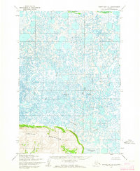
1952 Map of Hooper Bay D-1
USGS Topo · Published 1964About this map
The Askinuk Mountains dominate the southern coastline of this coastal Alaskan landscape, providing a rare stretch of elevated relief above the surrounding delta. This 1952 field-annotated study reveals an intricate aquatic network of meandering channels and tundra ponds characteristic of the Yukon-Kuskokwim Delta region. The Kun River and its major tributaries, including the Pungpuk River and the Kiknear River, wind through the lowlands, creating a labyrinth of waterways that define the local geography. Towards the southeast corner, the Kingokakthluk Lake sits near the base of the mountain range. This era of mapping, based on early 1950s aerial photography, captures the natural state of the coastal wetlands before significant modern environmental changes, offering a clear view of the traditional waterway connections across the tundra.
Find a feature on this map
5 named features on this map. Tap any name to fly to it.
Don’t see what you’re looking for? This feature index may not catch every label — zoom into the map to look around manually.
Map Details
Editions of this 1952 Hooper Bay D-1 Map
This is the sole edition of this map. No revisions or reprints were ever made.
Other maps of this area

1951 · Marshall
USGS Topo · 1:250,000

1951 · Hooper Bay
USGS Topo · 1:250,000

1951 · Black
USGS Topo · 1:250,000

1952 · Kwiguk
USGS Topo · 1:250,000

1952 · Black A-1
USGS Topo · 1:63,360

1952 · Kwiguk A-6
USGS Topo · 1:63,360
1952 · Marshall D-8
USGS Topo · 1:63,360
1952 · Marshall C-8
USGS Topo · 1:63,360
1952 · Hooper Bay C-1
USGS Topo · 1:63,360

1952 · Hooper Bay D-2
USGS Topo · 1:63,360