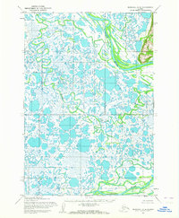
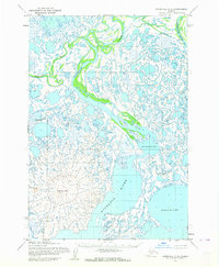
1952 Map of Marshall D-8
USGS Topo · Published 1964About this map
The Kashunuk River and Black River dominate this hydrologically complex landscape in the Yukon-Kuskokwim Delta region. Collected during the early 1950s using aerial photography, this survey records an intricate maze of thaw lakes, meandering sloughs, and marshy tundra where water and land are nearly indistinguishable. In the northeast corner, the Ulokat Hills provide the only significant topographic relief, rising above the low-lying plains. The Kun River snakes through the central and western portions of the sheet, illustrating the volatile nature of these Arctic waterways. A specific point of interest is Utukakarvik, a named location along a bend in the Black River that provides a rare geographic anchor in an otherwise uninhabited stretch of wilderness. The map is a meticulous study of subarctic drainage patterns before modern environmental changes altered these sensitive coastal ecosystems.
Find a feature on this map
5 named features on this map. Tap any name to fly to it.
Don’t see what you’re looking for? This feature index may not catch every label — zoom into the map to look around manually.
Map Details
Editions of this 1952 Marshall D-8 Map
2 editions found
Other maps of this area

1951 · Marshall
USGS Topo · 1:250,000

1951 · Hooper Bay
USGS Topo · 1:250,000

1951 · Black
USGS Topo · 1:250,000

1952 · Kwiguk
USGS Topo · 1:250,000

1952 · Black A-1
USGS Topo · 1:63,360

1952 · Kwiguk A-6
USGS Topo · 1:63,360
1952 · Hooper Bay D-1
USGS Topo · 1:63,360

1952 · Marshall C-7
USGS Topo · 1:63,360
1952 · Marshall D-7
USGS Topo · 1:63,360
1952 · Marshall C-8
USGS Topo · 1:63,360