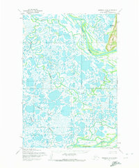
1952 Map of Marshall D-8
USGS Topo · Published 1972About this map
The Utukakarvik settlement sits along the winding path of the Black River in this survey of the Yukon-Kuskokwim Delta region. The landscape is defined by an intricate network of wetlands and tundra, where the Kun River and Tungpuk River carve through the flat coastal plain. In the northeast corner, the Kusilvak Mountains and Ulukat Hills provide the only significant topographic relief against the surrounding lowlands.
Find a feature on this map
9 named features on this map. Tap any name to fly to it.
Don’t see what you’re looking for? This feature index may not catch every label — zoom into the map to look around manually.
Map Details
Editions of this 1952 Marshall D-8 Map
2 editions found
Other maps of this area

1951 · Marshall
USGS Topo · 1:250,000

1951 · Hooper Bay
USGS Topo · 1:250,000

1951 · Black
USGS Topo · 1:250,000

1952 · Kwiguk
USGS Topo · 1:250,000

1952 · Black A-1
USGS Topo · 1:63,360

1952 · Kwiguk A-6
USGS Topo · 1:63,360
1952 · Hooper Bay D-1
USGS Topo · 1:63,360

1952 · Marshall C-7
USGS Topo · 1:63,360
1952 · Marshall D-7
USGS Topo · 1:63,360
1952 · Marshall D-8
USGS Topo · 1:63,360