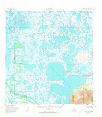
1952 Map of Kwiguk A-6
USGS Topo · Published 1973About this map
Nunavakanuk Lake dominates this mid-century landscape in the Yukon-Kuskokwim Delta region, a massive body of water surrounded by a complex system of smaller lakes and tundra ponds. The map captures the transitional period of the early 1950s, showing the neighboring settlements of New Knockhook and Knockhook situated along the winding bends of the Black River. These settlements, established along the river's active meanders, reflect the importance of waterways for transportation and subsistence in this part of Alaska. The northern portion of the sheet is defined by Anakshek Pass and the Ponglevik River, while the southeastern corner is anchored by the rising elevation of the Kusilvak Mountains. The intricate network of tidal channels and inland water bodies illustrates a landscape governed by the seasonal flow of the delta before modern infrastructure was introduced.
Find a feature on this map
7 named features on this map. Tap any name to fly to it.
Don’t see what you’re looking for? This feature index may not catch every label — zoom into the map to look around manually.
Map Details
Editions of this 1952 Kwiguk A-6 Map
2 editions found
Other maps of this area

1951 · Marshall
USGS Topo · 1:250,000

1951 · Hooper Bay
USGS Topo · 1:250,000

1951 · Black
USGS Topo · 1:250,000

1952 · Kwiguk
USGS Topo · 1:250,000

1952 · Black A-1
USGS Topo · 1:63,360

1952 · Black B-1
USGS Topo · 1:63,360

1952 · Kwiguk A-5
USGS Topo · 1:63,360

1952 · Kwiguk B-6
USGS Topo · 1:63,360

1952 · Kwiguk A-6
USGS Topo · 1:63,360

1952 · Kwiguk B-5
USGS Topo · 1:63,360