
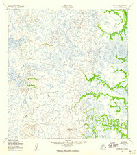
1952 Map of Kwiguk B-5
USGS Topo · Published 1959About this map
Ponglevik River and Anakshek Pass dominate the southern portion of this 1952 topographic study, revealing a complex web of waterways across the Kusilvak region. The terrain is characterized by a dense network of marshes and unnamed ponds, with drainage primarily facilitated by meandering channels like Igokluk Slough and the eastern Pektotolik Slough. Grounded in data from aerial photographs taken just after the war, the map provides precise elevation markers at several survey points, including VABM Berry 49 and VABM Last 83. A significant geographic landmark, Ungulungwak Hill, rises above the surrounding wetlands, serving as a primary triangulation station for the Army Map Service. This survey preserves the exact coastal hydrology and native nomenclature of the Yukon-Kuskokwim Delta area before modern shifts in the landscape.
Find a feature on this map
7 named features on this map. Tap any name to fly to it.
Don’t see what you’re looking for? This feature index may not catch every label — zoom into the map to look around manually.
Map Details
Editions of this 1952 Kwiguk B-5 Map
2 editions found
Other maps of this area

1952 · Kwiguk
USGS Topo · 1:250,000

1952 · Kwiguk A-5
USGS Topo · 1:63,360

1952 · Kwiguk C-6
USGS Topo · 1:63,360

1952 · Kwiguk B-6
USGS Topo · 1:63,360

1952 · Kwiguk A-6
USGS Topo · 1:63,360

1952 · Kwiguk C-4
USGS Topo · 1:63,360

1952 · Kwiguk A-4
USGS Topo · 1:63,360

1952 · Kwiguk C-5
USGS Topo · 1:63,360

1952 · Kwiguk B-4
USGS Topo · 1:63,360
2020 · Kwiguk A-4 NW
USGS Topo · 1:25,000