
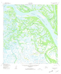
1952 Map of Kwiguk C-5
USGS Topo · Published 1959About this map
The Yukon River (Kwikluak Pass) dominates this subarctic landscape, where a intricate network of sloughs and passes creates a shifting delta environment in western Alaska. Small settlements and camps such as Akumauk, Lamont, and Tukukapak are scattered across the marshy terrain, connected primarily by the river and a Winter Trail that cuts across the frozen wetlands during the colder months. The map reveals the critical importance of water-based travel in the early 1950s, noted by the presence of a Seaplane Anchorage near the wide waters of Sunshine Bay. This area, surveyed during the post-war era of Alaskan mapping, shows a transition between major river channels like Akulurak Pass and narrower waterways like Kwimlilthla Slough, reflecting the seasonal movement and subsistence patterns of the region's inhabitants.
Find a feature on this map
21 named features on this map. Tap any name to fly to it.
Don’t see what you’re looking for? This feature index may not catch every label — zoom into the map to look around manually.
Map Details
Editions of this 1952 Kwiguk C-5 Map
2 editions found
Other maps of this area

1952 · Kwiguk
USGS Topo · 1:250,000

1952 · Kwiguk C-6
USGS Topo · 1:63,360

1952 · Kwiguk B-6
USGS Topo · 1:63,360

1952 · Kwiguk B-5
USGS Topo · 1:63,360

1952 · Kwiguk C-4
USGS Topo · 1:63,360

1952 · Kwiguk D-6
USGS Topo · 1:63,360

1952 · Kwiguk D-5
USGS Topo · 1:63,360

1952 · Kwiguk B-4
USGS Topo · 1:63,360

1952 · Kwiguk D-4
USGS Topo · 1:63,360
2020 · Kwiguk D-4 SW
USGS Topo · 1:25,000