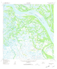
1952 Map of Kwiguk C-5
USGS Topo · Published 1959About this map
The Yukon River (Kwikluak Pass) dominates this sub-arctic landscape, carving a network of sloughs and passes through the marshy terrain of the Yukon Delta. Evidence of human presence and navigation is scattered across the wetlands, notably at the Seaplane Anchorage near Akumsuk and along the Winter Trail that cuts across the northern reaches. This 1952 record highlights the complex hydrology of the region, where waterways like Akularak Pass and Kwimlilthla Slough served as primary thoroughfares. The inclusion of Trogshak Ruins and several isolated cabins provides a window into the seasonal or historical habitations of the area, while settlements such as Lamont and Tukukapak mark more established points within the intricate riverine system of Sunshine Bay.
Find a feature on this map
23 named features on this map. Tap any name to fly to it.
Don’t see what you’re looking for? This feature index may not catch every label — zoom into the map to look around manually.
Map Details
Editions of this 1952 Kwiguk C-5 Map
2 editions found
Other maps of this area

1952 · Kwiguk
USGS Topo · 1:250,000

1952 · Kwiguk C-6
USGS Topo · 1:63,360

1952 · Kwiguk B-6
USGS Topo · 1:63,360

1952 · Kwiguk B-5
USGS Topo · 1:63,360

1952 · Kwiguk C-4
USGS Topo · 1:63,360

1952 · Kwiguk D-6
USGS Topo · 1:63,360

1952 · Kwiguk C-5
USGS Topo · 1:63,360

1952 · Kwiguk D-5
USGS Topo · 1:63,360

1952 · Kwiguk B-4
USGS Topo · 1:63,360

1952 · Kwiguk D-4
USGS Topo · 1:63,360