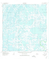
1952 Map of Black A-1
USGS Topo · Published 1975About this map
The Kipniyagok River and the Black River dominate this 1952 landscape in what is now the Kusilvak Census Area of Alaska. This is a region defined by its fluid geography, where meandering water bodies like Melatolik Creek and the Ear River weave through an intricate network of wetlands and tundra. The lack of permanent structures or settlements reflects the seasonal and nomadic patterns of land use in this part of the Yukon-Kuskokwim Delta.
Find a feature on this map
5 named features on this map. Tap any name to fly to it.
Don’t see what you’re looking for? This feature index may not catch every label — zoom into the map to look around manually.
Map Details
Editions of this 1952 Black A-1 Map
2 editions found
Other maps of this area

1951 · Marshall
USGS Topo · 1:250,000

1951 · Hooper Bay
USGS Topo · 1:250,000

1951 · Black
USGS Topo · 1:250,000

1952 · Kwiguk
USGS Topo · 1:250,000

1952 · Black A-2
USGS Topo · 1:63,360

1952 · Black A-1
USGS Topo · 1:63,360

1952 · Black B-1
USGS Topo · 1:63,360

1952 · Kwiguk B-6
USGS Topo · 1:63,360

1952 · Kwiguk A-6
USGS Topo · 1:63,360
1952 · Hooper Bay D-1
USGS Topo · 1:63,360