Old Maps of Chevak, Alaska for Academic Research
Study the evolution of Chevak with 5 high-resolution historic maps. Whether you're teaching, researching, or modeling changes in land use, these maps provide essential visual documentation of urban, environmental, and geographic change.
- Analyze long-term change: Track patterns in development, transportation, and natural features.
- Ideal for environmental or urban studies: Support academic projects with primary historical map data.
- Use in the classroom or lab: Educators and researchers rely on these maps to bring historical context to life.
These maps are a powerful tool for teaching, research, and visualizing how Chevak has changed over the decades.
Chevak, AK maps
(5)- 1951 Map of Hooper Bay
 1951 Hooper Bay1951 Print · USGSThe Yukon-Kuskokwim Delta coast is captured here just after the war, showing the remote settlements and river systems of the Bering Sea. You can trace the Winter Trail between Scammon Bay and Kutmiut or locate the old landing at Hooper Bay.
 - 1953 Map of Hooper Bay, 1963 Print
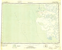
 1953 Hooper Bay1963 Print · USGSThe Bering Sea coast near the Yukon-Kuskokwim Delta appears here in the early fifties, showing a land of tidal rivers and tundra. Trace the locations of Hooper Bay, Chevak, and Old Chevak alongside the prominent As Kinuk Mountains.5 unique versions available
 - 1953 Map of Hooper Bay C-2, 1965 Print
 1953 Hooper Bay C-21965 Print · USGSThe remote Yukon-Kuskokwim Delta in the mid-fifties is a world of winding rivers and tundra lakes. Researchers can trace the traditional settlement of Chevak and the complex waterways of the Kokechik River, Kuttak River, and Ningikfak River.
 - 1964 Map of Hooper Bay
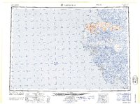 1964 Hooper Bay1964 Print · USGSCoastal Alaska's Yukon-Kuskokwim Delta is captured in the mid-sixties, a time when river travel and seasonal settlements defined the region. Genealogists and historians can trace the foundations of Hooper Bay and Chevak, or locate traditional sites like Paimiut and Old Chevak.
 - 2020 Map of Hooper Bay C-2 SW, 2020 Print
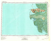
 2020 Hooper Bay C-2 SW2020 Print · USGSThe community of Chevak and its vital transport links are captured here in the early twenty-first century. Genealogists and researchers can trace the local street grid, including Aurora St, and find community landmarks like the PO and Chevak Airport.
End of results
Showing maps 1-5 of 5
Frequently asked questions
- What are the different types of historical maps available for Chevak?
- What is the oldest map of Chevak?
- Where can I purchase historical maps of Chevak for my home or office?
- Where can I download high-res historical maps of Chevak?
- Are there historical topographic maps available for Chevak?
- Is there historical aerial imagery available for Chevak?
- Where are historical maps of Chevak sourced from?